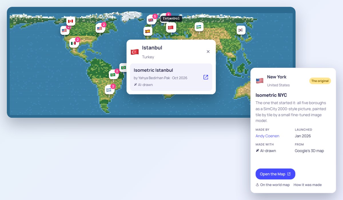
Drag to move, scroll to zoom. Click a flag to see its maps.
New
Isometrisch Helenaveen
A small peat village in miniature, every house, greenhouse and tree in its real place, drawn in code from open data.
- Launched
- Nov 2026
- Made with
- Drawn from open data
- From
- Open data
New
Tiny BH
Downtown Belo Horizonte, redrawn building by building by an image model.
- Launched
- Nov 2026
- Made with
- AI-drawn
- From
- Google's 3D map
New
Seoul Miniature: Gyeongbokgung
The streets round Gyeongbokgung Palace in pixel art, with the time, season and weather changing and people and cars on the move.
- Launched
- Nov 2026
- Made with
- Drawn from open data
- From
- Mixed sources
Live weatherDay and night
New
Isometric Milwaukee
Downtown Milwaukee as one giant illustration painted by AI, from the Art Museum to the Domes.
- Launched
- Nov 2026
- Made with
- AI-drawn
- From
- Google's 3D map
Address search
🇺🇸San FranciscoUnited States
New
San Francisco, isometric
The whole city as one continuous cartoon map, painted in about eight hours on a single GPU.
- Launched
- Nov 2026
- Made with
- AI-drawn
- From
- Not stated
New
Isometric World: Tel Aviv-Yafo
36,604 buildings from the city's open data, with 230,452 trees where the city's tree map puts them.
- Launched
- Nov 2026
- Made with
- AI-drawn
- From
- Open data
New
Pixel Hyderabad
Hyderabad from HITEC City to the Old City, some 18 by 11 km, drawn as pixel art from map and elevation data.
- Launched
- Nov 2026
- Made with
- Drawn from open data
- From
- OpenStreetMap
New
Tiny Paris
All of Paris and La Défense, 109,000 buildings at their lidar heights, with traffic, buses, métros and boats on the move.
- Launched
- Nov 2026
- Made with
- AI-drawn
- From
- Mixed sources
Live transit
New
Isometric Malta
All three islands, Malta, Gozo and Comino, with cars, buses, boats and people on the real roads, and past eras of how the islands grew.
- Launched
- Nov 2026
- Made with
- AI-drawn
- From
- Mixed sources
Live transit
Isometric Luxembourg
Central Luxembourg City as an inked and painted illustration that follows the real clock, with trams and trains on the timetable and 47 landmarks.
- Launched
- Nov 2026
- Made with
- AI-drawn
- From
- Not stated
Day and nightLive transit
TinyLyon
Lyon's nine arrondissements and Villeurbanne in pixel art, with trams, landmark postcards and modes to drive, fly or race.
- Launched
- Nov 2026
- Made with
- AI-drawn
- From
- Mixed sources
Live transitFlight mode
Isometric Mumbai
All of Greater Mumbai, from Colaba to Dahisar, built from 1.2 million building outlines and drawn as pixel art, with kaali-peeli taxis, buses and local trains.
- Launched
- Nov 2026
- Made with
- AI-drawn
- From
- Building footprints and heights
Live transit
Isometric Seattle
Central Seattle from Ballard and the university down to the stadiums, Harbor Island and Alki, traced tile by tile.
- Launched
- Nov 2026
- Made with
- AI-drawn
- From
- Google's 3D map
Pixel Singapore
About eight by six kilometres round Marina Bay with traffic, birds and swaying trees, and a switch between 2016 and today.
- Launched
- Nov 2026
- Made with
- AI-drawn
- From
- Not stated
🇺🇸State CollegeUnited States
Isometric State College
State College and Penn State's campus in SimCity 2000 style, in seven seasons and times of day.
- Launched
- Nov 2026
- Made with
- AI-drawn
- From
- Google's 3D map
Day and night
tiny athens
Athens as a small pixel-art map.
- Launched
- Nov 2026
- Made with
- AI-drawn
- From
- Not stated
Tiny Madrid
An illustrated Madrid from the city council's 3D model, in a Windows 98-style window, with a monuments guide and modes to drive or fly.
- Launched
- Nov 2026
- Made with
- AI-drawn
- From
- The city's 3D model
Address searchFlight mode
Tiny Orindiúva
A small town in São Paulo state as a toy-like city of its 2,316 real buildings, with the local weather.
- Launched
- Nov 2026
- Made with
- Drawn from open data
- From
- OpenStreetMap
Live weather
Postcard Roads: Paris
All of Paris from a driving game, down to the streets, with cars and people.
- Launched
- Nov 2026
- Made with
- 3D diorama
- From
- Open data
Tiny Rome
Eight kilometres of Rome as one inked and hand-coloured picture, with a history mode that plays 2,700 years where they happened.
- Launched
- Nov 2026
- Made with
- AI-drawn
- From
- Google's 3D map
Tours
Tiny Tirana
The whole city, the airport and Mount Dajti in pixel art, with 46 landmarks to read about, buses to ride and the Dajti cable car.
- Launched
- Nov 2026
- Made with
- AI-drawn
- From
- Google's 3D map
Live transitTours
Tiny Barcelona
Barcelona as a game map in 135 tiles, from Montjuïc to the Sagrada Família and the port, with 29 landmarks and a little flight mode.
- Launched
- Nov 2026
- Made with
- AI-drawn
- From
- Google's 3D map
Flight mode
In progress
Tiny Toronto #2
Toronto from the lake northwards as an illustrated, zoomable map redrawn tile by tile, with the rest of the Greater Toronto Area to come.
- Launched
- Nov 2026
- Made with
- AI-drawn
- From
- Aerial imagery
🇺🇸AlbuquerqueUnited States
Isometric Albuquerque
The metro area from the Sandia crest to the West Mesa volcanoes, drawn from map and elevation data.
- Launched
- Nov 2026
- Made with
- Drawn from open data
- From
- OpenStreetMap
Brasília Isocity
Niemeyer’s modernist capital as a tiny pixel-art city, painted by Qwen Image Edit on a single home graphics card.
- Launched
- Nov 2026
- Made with
- AI-drawn
- From
- Google's 3D map
Address search
Isometric Kraków
The whole of Kraków drawn live in the browser, from Wawel and the Main Square to Kazimierz, by day, dusk, night or in winter.
- Launched
- Nov 2026
- Made with
- Drawn from open data
- From
- Open data
Day and nightLive transit
Isometric New York
A drawn New York you can zoom into, walk at street level or fly a plane over; double-click a street to drop down into it.
- Launched
- Nov 2026
- Made with
- Drawn from open data
- From
- NYC Open Data and OpenStreetMap
Flight mode
🇺🇸San FranciscoUnited States
Isometric SF
The entire Bay Area, over 1,300 square miles, as one pixel-art picture painted by a small image model, with place search.
- Launched
- Nov 2026
- Made with
- AI-drawn
- From
- Google's 3D map
Address search
🇺🇸San FranciscoUnited States
Isometric San Francisco
Every building in San Francisco from public lidar and city data, as an illustration or in pixel art.
- Launched
- Nov 2026
- Made with
- AI-drawn
- From
- Lidar and open data
In progress
Tiny Toronto #1
A painted Toronto where every building is real and named when you point at it, with weather, day and night, and raccoons to find.
- Launched
- Nov 2026
- Made with
- AI-drawn
- From
- Google's 3D map
Clickable buildingsLive weatherDay and night
İzometrik Türkiye
A whole country rather than a city: 441 places across Türkiye, from Anıtkabir to Nemrut and Cappadocia, each as its own miniature relief, listed province by province.
- Launched
- Nov 2026
- Made with
- 3D diorama
- From
- Relief models
Address search
Isometric Vancouver
Nearly all of the City of Vancouver as one illustration, redrawn tile by tile by an image model, with traffic on its streets.
- Launched
- Nov 2026
- Made with
- AI-drawn
- From
- Google's 3D map
In progress
tiny frankfurt
The skyline, the Altstadt and Sachsenhausen first, redrawn square by square, with life on the river and the roads.
- Launched
- Nov 2026
- Made with
- AI-drawn
- From
- Google's 3D map
In progress
TinySP
São Paulo in pixel art from Avenida Paulista to Ibirapuera, with day and night tiles and a search for any place.
- Launched
- Nov 2026
- Made with
- AI-drawn
- From
- OpenStreetMap
Address searchDay and night
MiniSP
Downtown São Paulo in isometric pixel art.
- Launched
- Nov 2026
- Made with
- AI-drawn
- From
- Google's 3D map
Isometric Kinderdijk
All nineteen windmills of Kinderdijk, from Dutch 3D building and terrain data, redrawn as pixel art with their stories.
- Launched
- Nov 2026
- Made with
- AI-drawn
- From
- Open data
Tours
🇺🇸Los AngelesUnited States
Isometric Los Angeles
Los Angeles from the Valley down to the harbour as one huge isometric picture, made the tiny.london way.
- Launched
- Nov 2026
- Made with
- AI-drawn
- From
- Google's 3D map
Tiny Prague #3
All of Prague redrawn from Google Earth by a fine-tuned Qwen model, with place search and the metro and tram lines on top.
- Launched
- Nov 2026
- Made with
- AI-drawn
- From
- Google Earth
Address search
In progress
Isometric Toronto
The old City of Toronto from the Humber to the Beaches as one seamless picture, with live streetcars, the real sunset and planes at Billy Bishop.
- Launched
- Nov 2026
- Made with
- AI-drawn
- From
- Google's 3D map
Live transitDay and nightFlight mode
Warsaw in voxels
Warsaw built from voxels as a 3D scene.
- Launched
- Nov 2026
- Made with
- 3D diorama
- From
- Not stated
Isometric Ankara
Ankara from Sincan to Mamak, with Anıtkabir, Kızılay, Ulus and the castle.
- Launched
- Nov 2026
- Made with
- Drawn from open data
- From
- Open data
Imperatriz em miniatura
The city of Imperatriz in Maranhão as a 3D miniature.
- Launched
- Nov 2026
- Made with
- 3D diorama
- From
- Not stated
Isometric Paris
Central Paris from the Eiffel Tower to Père Lachaise, its 77,000 buildings at their mapped heights; tap a place to read about it.
- Launched
- Nov 2026
- Made with
- Drawn from open data
- From
- OpenStreetMap
Clickable buildings
isotokyo
All 23 special wards of Tokyo in one map, drawn by an image model.
- Launched
- Nov 2026
- Made with
- AI-drawn
- From
- Not stated
Tiny València
The whole municipality, from the huerta to the Albufera lagoon, painted block by block as one pixel-art map.
- Launched
- Nov 2026
- Made with
- AI-drawn
- From
- Not stated
Isometric Vienna
Vienna from Schönbrunn to Donau City with trams and boats on the move, the Riesenrad lit at night and places to tap.
- Launched
- Nov 2026
- Made with
- Drawn from open data
- From
- OpenStreetMap
Day and nightClickable buildings
Tiny Belgrade
New Belgrade, Zemun, the old town, Kalemegdan and Great War Island from 714 redrawn tiles stitched into 457 megapixels.
- Launched
- Oct 2026
- Made with
- AI-drawn
- From
- Google's 3D map
Address search
Leuven Social
Leuven's historic centre inside the ring road as a tiny 3D pixel city to walk round or cycle through on a borrowed bike.
- Launched
- Oct 2026
- Made with
- Drawn from open data
- From
- Open data
Tiny Prague #1
The whole of Prague drawn live from the city’s open data with no image model, with real roofs, live trams, night lights and 14 viewpoints.
- Launched
- Oct 2026
- Made with
- Drawn from open data
- From
- The city's open 3D data and OpenStreetMap
Live transitDay and nightClickable buildingsTours
Tiny Prague #2
A low-poly 3D Prague with every tram, bus, metro train and plane live, an underground metro view, route planning and weather.
- Launched
- Oct 2026
- Made with
- 3D diorama
- From
- OpenStreetMap and Czech land survey data
Live transitDay and nightLive weatherFlight modeAddress search
In progress
Tiny Rio
Rio de Janeiro as isometric pixel art, between the mountains and the beaches, with a plane to fly over it.
- Launched
- Oct 2026
- Made with
- AI-drawn
- From
- Google's 3D map
Flight mode
In progress
Isometric Amsterdam
The historic centre with every one of its 68,000 buildings at its real height, canals and trees; landmarks are being redrawn one by one.
- Launched
- Oct 2026
- Made with
- Drawn from open data
- From
- Open building data
MiniDF
The Federal District in pixel art, with capybaras to spot and a Where's Flávio game.
- Launched
- Oct 2026
- Made with
- AI-drawn
- From
- Google's 3D map
Kraków w pikselach
All of Kraków as a 3D pixel-art map with a timeline of sixteen eras from 965 to today, trams on the timetable and lit windows at night.
- Launched
- Oct 2026
- Made with
- 3D diorama
- From
- Not stated
Day and nightLive transit
Isometric Bielsko-Biała
The whole city drawn live from open data and lidar, with the real sun, four seasons and buses where they are right now.
- Launched
- Oct 2026
- Made with
- 3D diorama
- From
- Open data and lidar
Day and nightLive weatherLive transit
Isometric Istanbul
The European and Asian shores of the Bosphorus, from the city’s own 3D model, repainted by a fine-tuned Qwen image model.
- Launched
- Oct 2026
- Made with
- AI-drawn
- From
- The city's 3D model
JF em Pixels
Juiz de Fora, Minas Gerais, in isometric pixel art, full of facts about the city and little games to play.
- Launched
- Oct 2026
- Made with
- AI-drawn
- From
- Google's 3D map
Hype Seoul
Seoul as one isometric painting, with day and night following Seoul’s own clock and subway trains moving through it.
- Launched
- Oct 2026
- Made with
- AI-drawn
- From
- Google's 3D map
Live transitDay and night
In progress
Tiny Stockholm
Stockholm with Solna and Sundbyberg, painted in the tiny.london style, with trains, buses and ferries on their timetables.
- Launched
- Oct 2026
- Made with
- AI-drawn
- From
- Google's 3D map
Live transit
Isometric Málaga
The coast, the cathedral, the port, the bullring and Gibralfaro hill in some 2.4 gigapixels of pixel art.
- Launched
- Oct 2026
- Made with
- AI-drawn
- From
- Google's 3D map
In progress
Tiny Goiânia
Goiânia repainted as an isometric pixel-art map from its 3D model.
- Launched
- Oct 2026
- Made with
- AI-drawn
- From
- Google's 3D map
010
Rotterdam in miniature from its 3D model, with real sunlight, windows lit at night and the current weather.
- Launched
- Oct 2026
- Made with
- 3D diorama
- From
- The city's 3D model
Day and nightLive weather
Isometric Warsaw
The whole city in pixel art, drawn live in your browser from open data rather than generated, with trams and trains running to the timetable.
- Launched
- Oct 2026
- Made with
- Drawn from open data
- From
- Open data (GUGiK)
Live transit
tiny.london
The whole of Greater London in one zoomable isometric pixel-art picture, and the home of a world map of the others.
- Launched
- Oct 2026
- Made with
- AI-drawn
- From
- Google's 3D map
🇻🇳Ho Chi Minh CityVietnam
Saigon Rush Hour
District 1 at rush hour as an isometric traffic simulator on the real streets, with motorbikes, cars and buses.
- Launched
- Oct 2026
- Made with
- 3D diorama
- From
- OpenStreetMap
Live transit
Tiny Brussels
The EU quarter round Schuman as a living miniature with today's weather and time of day, trams, the Sunday market and favourite cafés.
- Made by
- Unknown
- Launched
- Oct 2026
- Made with
- 3D diorama
- From
- The region's 3D model
Live weatherDay and nightLive transit
Tiny Casablanca
Downtown Casablanca, from Place des Nations Unies to the old medina, in pixel art.
- Launched
- Oct 2026
- Made with
- AI-drawn
- From
- Not stated
🇺🇸CincinnatiUnited States
Iso Cincy
Greater Cincinnati's 34,000 buildings as a city-builder world that follows the time, the weather and the Ohio river, with a mural tour and daily games.
- Made by
- Unknown
- Launched
- Oct 2026
- Made with
- 3D diorama
- From
- Not stated
Live weatherDay and nightTours
Tiny Rampage
A pixel-art London built for a bit of monster-movie destruction.
- Launched
- Oct 2026
- Made with
- AI-drawn
- From
- Not stated
🇺🇸San FranciscoUnited States
North Beach Isometric
A small demo: the streets round Coit Tower in North Beach as an isometric pixel mosaic.
- Launched
- Sep 2026
- Made with
- AI-drawn
- From
- Google's 3D map
Earth to Pixels: João Pessoa
João Pessoa in SimCity style, from the 3D map through a fine-tuned open Qwen model.
- Launched
- Sep 2026
- Made with
- AI-drawn
- From
- Google's 3D map
🇺🇸Athens, GeorgiaUnited States
Walk North Campus
The University of Georgia's North Campus as a little isometric world to walk around.
- Launched
- Sep 2026
- Made with
- Drawn from open data
- From
- OpenStreetMap
Isometric Cities: Montreal
Griffintown and Old Montreal as one pixel-art map, after Isometric NYC.
- Launched
- Sep 2026
- Made with
- AI-drawn
- From
- Google's 3D map
Pixel Adelaide
Every building at its real height, with the businesses inside them on cards.
- Made by
- Grigory Frolov
- Launched
- Sep 2026
- Made with
- Drawn from open data
- From
- Not stated
Clickable buildings
SimLeón
León, Guanajuato in SimCity 2000 style, limited to a palette of 256 colours.
- Launched
- Sep 2026
- Made with
- AI-drawn
- From
- Google's 3D map
Pixel Perth
Perth with every building at its real height and the businesses inside on cards.
- Made by
- Grigory Frolov
- Launched
- Sep 2026
- Made with
- Drawn from open data
- From
- Not stated
Clickable buildings
Isometric Cities: Ottawa
Parliament Hill and central Ottawa along the river as a pixel-art sample, after Isometric NYC.
- Launched
- Aug 2026
- Made with
- AI-drawn
- From
- Google's 3D map
Isometric Cities: Victoria
The Inner Harbour and the BC Legislature as a pixel-art sample, after Isometric NYC.
- Launched
- Aug 2026
- Made with
- AI-drawn
- From
- Google's 3D map
London, drawn
Over 200 square kilometres of central London redrawn square by square, with almost two hundred landmark buildings to open.
- Launched
- Aug 2026
- Made with
- AI-drawn
- From
- Google's 3D map
Clickable buildings
🇺🇸San FranciscoUnited States
Isopolis San Francisco
San Francisco as one huge isometric pixel painting, with guided tours and postcards.
- Launched
- Aug 2026
- Made with
- AI-drawn
- From
- Google's 3D map
Tours
Pixel Gold Coast
The Gold Coast with every building at its real height and the businesses inside on cards.
- Made by
- Grigory Frolov
- Launched
- Aug 2026
- Made with
- Drawn from open data
- From
- Not stated
Clickable buildings
Pixel Melbourne
Melbourne with every building at its real height and the businesses inside on cards.
- Made by
- Grigory Frolov
- Launched
- Aug 2026
- Made with
- Drawn from open data
- From
- Not stated
Clickable buildings
🇦🇺Sunshine CoastAustralia
Pixel Sunshine Coast
The Sunshine Coast with every building at its real height and the businesses inside on cards.
- Made by
- Grigory Frolov
- Launched
- Aug 2026
- Made with
- Drawn from open data
- From
- Not stated
Clickable buildings
Pixel Sydney
Sydney with every building at its real height and the businesses inside on cards.
- Made by
- Grigory Frolov
- Launched
- Aug 2026
- Made with
- Drawn from open data
- From
- Not stated
Clickable buildings
Isometric Cities: Toronto
Downtown Toronto as a pixel-art sample from the same series as the Montreal, Ottawa and Victoria maps.
- Launched
- Aug 2026
- Made with
- AI-drawn
- From
- Google's 3D map
Pixel Brisbane
The first of a set of Australian cities with every building at its real height and the businesses inside on cards.
- Made by
- Grigory Frolov
- Launched
- Jul 2026
- Made with
- Drawn from open data
- From
- Not stated
Clickable buildings
NYC Permit Pulse
New York's building permits shown on the isometric city, building by building.
- Launched
- Mar 2026
- Made with
- AI-drawn
- From
- Not stated
Clickable buildings
Isometric Atlanta
Atlanta as an isometric pixel-art map, one of the earliest after Isometric NYC.
- Launched
- Feb 2026
- Made with
- AI-drawn
- From
- Not stated
The original
Isometric NYC #1
The one that started it: all five boroughs as a SimCity 2000-style picture, painted tile by tile by a small fine-tuned image model.
- Launched
- Jan 2026
- Made with
- AI-drawn
- From
- Google's 3D map
Abidjan Plateau
Le Plateau, the business district, built up building by building from OpenStreetMap and aerial photos, its towers named.
- Made with
- AI-drawn
- From
- OpenStreetMap and aerial photos
Clickable buildings
Isometric Beijing
The Forbidden City, the CBD and the Olympic park as an isometric 3D map.
- Made by
- Unknown
- Made with
- 3D diorama
- From
- Not stated
In progress
BLR Mini
Greater Bengaluru with Namma Metro, city wards and the weather; the pixel art is still being painted in.
- Made with
- AI-drawn
- From
- Google's 3D map
Live transitLive weather
How Bangalore moves
Bengaluru drawn in code to show how the city moves.
- Made with
- Drawn from open data
- From
- Not stated
Isometric Bengaluru
Bengaluru as an isometric map drawn in code.
- Made with
- Drawn from open data
- From
- Not stated
Pixel Berlin
All of Berlin in a calm, muted isometric palette, painted by a Qwen LoRA, with a search to jump to any address.
- Made with
- AI-drawn
- From
- Google's 3D map
Address search
Isometric Berlin
The government quarter round the Reichstag as a walkable 3D scene, built from Berlin’s official 3D city model.
- Made with
- 3D diorama
- From
- Berlin's official 3D model and OpenStreetMap
Berlin Field Atlas
An architecture guide to 121 Berlin landmarks on an isometric 3D map, with photos and field notes.
- Made with
- 3D diorama
- From
- Not stated
Clickable buildings
Wedding, gezeichnet
Berlin's Wedding district, drawn as one illustrated map.
- Made with
- AI-drawn
- From
- Not stated
CABA Isométrica
Buenos Aires in SimCity style, stitched together from more than 12,000 generated pictures.
- Made by
- Nicolás Poore
- Made with
- AI-drawn
- From
- Google's 3D map
🇺🇸BurlingtonUnited States
Isometric Burlington
Burlington, South Burlington and Winooski in Vermont from four angles you can turn, with the real sunset and weather, buses on their timetable and live planes overhead.
- Made with
- AI-drawn
- From
- Mixed sources
Live weatherDay and nightLive transitAddress search
Pixel Chennai
Greater Chennai from Ennore Port to Mahabalipuram: drawn from open map data as a plain isometric map, then repainted tile by tile by an image model. The AI layer can be switched off.
- Made with
- AI-drawn
- From
- Open data
Address search
Tiny Curitiba #1
Curitiba redrawn from 3D imagery by a Qwen image model.
- Made with
- AI-drawn
- From
- Google's 3D map
Tiny Curitiba #2
A second Curitiba in pixel art, made from real imagery of the city.
- Made with
- AI-drawn
- From
- Not stated
Izometrická 3D mapa ČR
The whole of Czechia as an isometric 3D map built from OpenStreetMap.
- Made with
- 3D diorama
- From
- OpenStreetMap
Tiny Detroit
The City of Detroit as one pixel-art picture painted by a Qwen LoRA, with the QLine streetcar and the People Mover.
- Made with
- AI-drawn
- From
- Google's 3D map
Live transit
Edirne Isometric
Central Edirne from real map geometry, with its landmarks illustrated.
- Made with
- Drawn from open data
- From
- OpenStreetMap
Ericeira Map
The surf town of Ericeira as one big picture, a homage to the city builders of the 1990s: a 3D render redrawn tile by tile in flat cel-shaded colour by an image model.
- Made with
- AI-drawn
- From
- Google's 3D map
Address search
Tiny Floripa
The Centro of Florianópolis and the Hercílio Luz bridge from the city’s open data, with pixel art, outline and aerial photo views to switch between.
- Made by
- Unknown
- Made with
- 3D diorama
- From
- Mixed sources
Tiny Geneva
Geneva as a tiny 3D city.
- Made by
- Onat Behic
- Made with
- 3D diorama
- From
- Not stated
Isometric Istanbul: Day & Night
Galata, Karaköy and northern Eminönü in close detail, by day or by night.
- Made by
- Unknown
- Made with
- AI-drawn
- From
- Not stated
Day and night
Koyland
A browser strategy game on isometric Istanbul: found a village on the real map and lay siege to your rivals.
- Made with
- Drawn from open data
- From
- Open data
Multiplayer
Mini Lagos
Lagos as a miniature 3D map.
- Made with
- 3D diorama
- From
- Not stated
🇺🇸Lake TahoeUnited States
Tahoe Trails
The trails round Lake Tahoe as an isometric 3D landscape.
- Made with
- 3D diorama
- From
- Not stated
tiny lisbon
Lisbon from Belém to Parque das Nações as one zoomable pixel-art map.
- Made with
- AI-drawn
- From
- Google's 3D map
Ziemia Pikselowa
Łódź in the style of old games, its buildings, trees, trams and trains drawn from open data, with small map games such as a bike courier run.
- Made with
- Drawn from open data
- From
- Open data
Isometric London
A giant pixel-art map of central London drawn entirely in code from OpenStreetMap, with no AI images.
- Made with
- Drawn from open data
- From
- OpenStreetMap
London Field Atlas
An architecture guide to 289 London buildings on an isometric 3D map, with photos and field notes.
- Made with
- 3D diorama
- From
- Open data
Clickable buildings
CDMX Isométrico
Mexico City in pixel art, drawn in the browser from OpenStreetMap, from the historic centre to Xochimilco.
- Made by
- Unknown
- Made with
- Drawn from open data
- From
- OpenStreetMap
🇬🇧Milton KeynesUnited Kingdom
ICanSee.MK
Districts of Milton Keynes, each painted by a different AI image model, so their styles can be compared side by side.
- Made by
- Unknown
- Made with
- AI-drawn
- From
- Google's 3D map
Little Mississauga
The whole city in a RollerCoaster Tycoon 3 style, with parks, cycling routes and city facilities as layers and the live weather and time of day.
- Made with
- AI-drawn
- From
- Open data
Live weatherDay and night
In progress
Tiny Montréal
Montréal rebuilt from open data and painted by a small image model, with boats on the river, live weather, and seasons and night to switch to.
- Made by
- Unknown
- Made with
- AI-drawn
- From
- Open data
Live weatherDay and night
Neuquén Isométrico
An arcade-style flight over a pixel-art Neuquén, taking off from its flag monument.
- Made with
- AI-drawn
- From
- Google's 3D map
Flight mode
Isometric NYC #2
All five boroughs drawn in code from the city’s open data and lidar, which you can rotate and light for night, morning or golden hour.
- Made by
- Unknown
- Made with
- Drawn from open data
- From
- NYC Open Data, lidar and OpenStreetMap
Day and night
tiny.ottawa
Ottawa and the Gatineau core as one illustration made with a Qwen image model, with live weather, car traffic and O-Train and city-life layers.
- Made with
- AI-drawn
- From
- Mixed sources
Live weatherAddress search
Petit Paris
All of Paris inside the périphérique, 128,000 real buildings in 3D by day or night, with address search, a car to drive and rooms to share with friends.
- Made by
- Unknown
- Made with
- 3D diorama
- From
- Open data
Day and nightAddress searchMultiplayer
Paris en pixels
Paris inside the Périphérique in isometric pixel art, from the Louvre to Notre-Dame, sharp at every zoom level.
- Made by
- Unknown
- Made with
- AI-drawn
- From
- Not stated
🇺🇸PhiladelphiaUnited States
IsoPhilly
Philadelphia as an isometric map drawn in code.
- Made with
- Drawn from open data
- From
- Not stated
tiny pyongyang
Kim Il Sung Square, the Juche Tower, the Ryugyong Hotel and every central district, with the real clock, weather and season of Pyongyang. By the maker of tiny tashkent.
- Made with
- AI-drawn
- From
- OpenStreetMap
Address searchLive weatherDay and night
Raleigh Terrarium
Little floating worlds of North Carolina to orbit, walk, fly or kayak through, in a dozen looks including pixel art.
- Made with
- 3D diorama
- From
- Open data
Flight mode
SimRosario
All of Rosario inside the ring road as it looked in 2012–2013, redrawn from oblique aerial photos by an image model trained for the project, with landmarks checked by hand.
- Made with
- AI-drawn
- From
- Google's aerial photos
Tiny SP
From Avenida Paulista down to the Jardins, Pinheiros, Itaim and Ibirapuera as a little game map, with the homes for sale in each building.
- Made with
- AI-drawn
- From
- Google's 3D map
Clickable buildings
TinySeoul
Seoul as a live 3D miniature from the national 3D map: light it for night, crop any spot and export it as a PNG or an SVG drawing.
- Made by
- Unknown
- Made with
- 3D diorama
- From
- Korea's national 3D map (VWorld)
Day and nightAddress search
Tiny Tashkent
The whole of Tashkent as an illustrated isometric map, with a search in Latin or Cyrillic letters.
- Made with
- AI-drawn
- From
- Streets and buildings data
Address search
Isometric Tehran
Tehran's historic core, the Grand Bazaar, Golestan Palace, Toopkhaneh Square and Lalehzar, in English and Persian.
- Made with
- AI-drawn
- From
- Not stated
In progress
Tiny Vancouver
A sunny pixel-art Vancouver with place names, evening light and a little flight mode.
- Made by
- Unknown
- Made with
- AI-drawn
- From
- Google's 3D map
Day and nightFlight mode
Isometric Cities: Vancouver
Vancouver as a pixel-art sample from the same series as the Montreal, Ottawa and Victoria maps.
- Made with
- AI-drawn
- From
- Google's 3D map
Tiny Venezia
San Marco, the Rialto and the Salute drawn with a Gemini image model, with the water of the canals moving.
- Made with
- AI-drawn
- From
- Not stated
Pixel ES
The Vila Velha seafront from Itaparica to Jardim da Penha in Espírito Santo, with day and night, live weather and cars that drive when you zoom in.
- Made with
- 3D diorama
- From
- Mixed sources
Day and nightAddress searchLive weather
Tiny Warsaw
A low-poly 3D diorama of Warsaw with hand-made landmarks, real flights at the airport, day and night, rides and flying with friends.
- Made with
- 3D diorama
- From
- OpenStreetMap and GUGiK heights
Flight modeDay and nightMultiplayer

 Text Tools
 Image Tools
 PDF Tools
 Social Media Tools
 Security Tools
 Coding Tools
 CSS Tools
 Color Tools
 Miscellaneous Tools
 Add to Chrome
 Add to Firefox